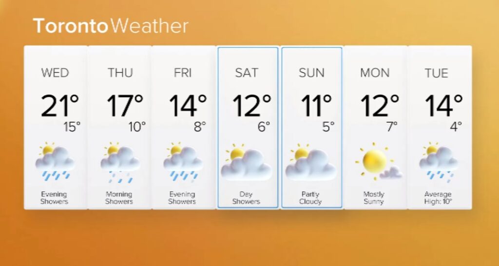
A spell of warm fall weather continues to sweep across the Greater Toronto Area (GTA) with a potentially record-breaking temperature day in store for Wednesday.
“The remarkable November warmth continues today. We have seen outstanding conditions since the start of the month, well above seasonal,” said weather specialist Denise Andreacchi.
The forecast calls for a high of 21 C, which Andreacchi said could break a record set back in 1987 when the temperature hit 20.1 C.
“It’s going to be close, but we definitely have the chance [Wednesday],” she said. “Winds out of the south picking up to 40 kilometres an hour at times, they’re ushering in all of this mild air.”
The day started off with a mix of sun and cloud, but showers are expected late in the day and continue tonight as the temperature drops to 14 C.

The balmy weather is expected to change course for the rest of the work and school week with highs between 14-16 C. Periods of rain are forecasted for Friday night, as the low drops to single digits, around 6 C.
Then, cooler temperatures are on the way for the weekend, around 10-12 C for Saturday and Sunday and overnight lows near 5 C.
Environment and Climate Change Canada (ECCC) said the rest of November will likely see above normal temperatures on average across the country.
“This warmth is extending into northern Ontario too, so we are seeing record-breaking warmth through the northern parts of the province,” added Andreacchi.
Click here for the current and extended forecast.
Impact of warmer weather on mosquitoes
Experts say mosquitoes seem to be living longer this fall in parts of southern and eastern Ontario and elsewhere across Canada because of warmer-than-usual temperatures.
Mosquitoes typically thrive in warm and humid environments and these conditions have been extended by this year’s strong El Niño — a natural phenomenon that causes global temperatures to spike every few years.
CityNews chief meteorologist Natasha Ramsahai has said the incoming El Niño pattern could be the strongest on record based on the latest National Oceanic and Atmospheric Administration (NOAA) forecast.
El Niño is a cycle that usually alternates every two to seven years with La Niña (cooler-than-normal temperatures) and neutral conditions.
With files from The Canadian Press